Showing posts with label gannets. Show all posts

Monday, September 04, 2017

Newfoundland Wrapup (#7)

It's taken me longer than I thought to get to this post, my apologies, loyal readers! And I probably should have split this into two posts, but as long as I was writing...

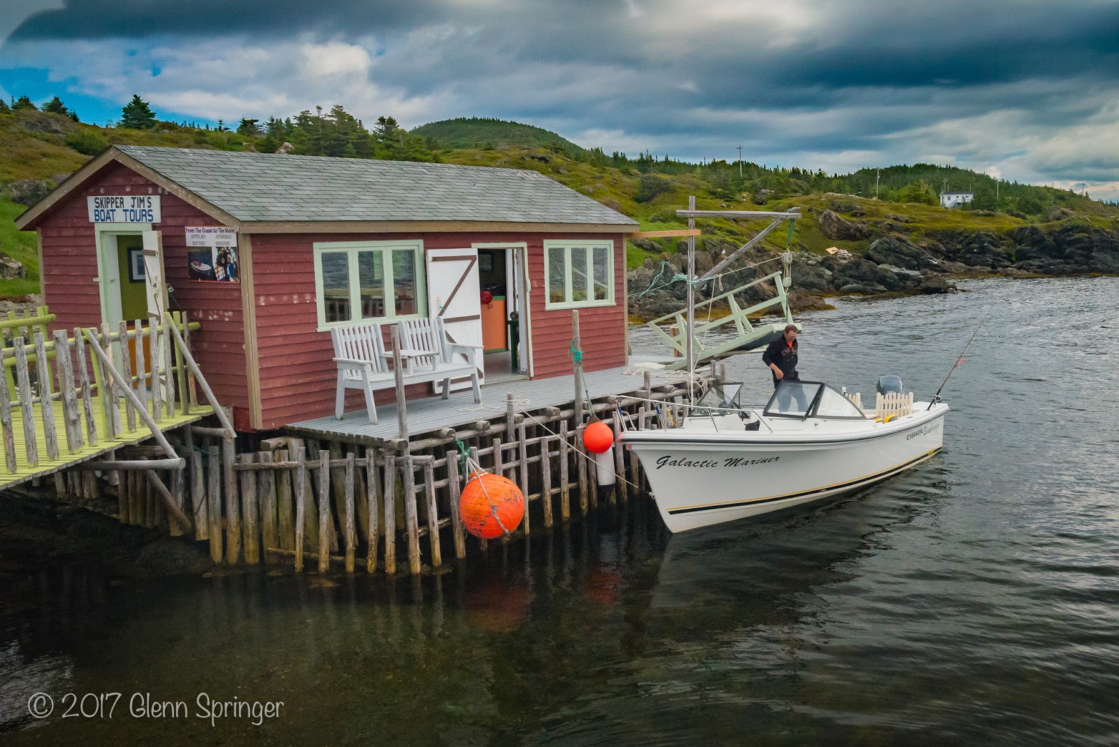
I spent 3 days in the Cape St. Mary area in the vain hope that the fog would dissipate and I'd be able to return to the Gannet rock. The port in St. Brides, which I could have seen from my motel had it not been foggy was quiet but a few boats came in to unload their catch of cod, guided by the plaintive call of the foghorn every 30 seconds. It is a small port, boats ganged up 2 by 2 on the pier, manned by hard men and brash teenage lads, some of whom captained their own boats. All of whom took the time to share a friendly moment with a photographer "from away", in typical Newfoundlander fashion.


The young lad in the blue shirt captains the black boat in the previous picture. It must be a family thing because a lot of boats had "Dohey's" in the name 


Crowded port. These boats docked with inches to spare. 


Room for 3 more boats on this side of the pier 


Cod fishing is still a "thing" in Newfoundland but quotas are restrictive for commercial boats, and strictly enforced. The Ministry of Fisheries is present when the catch is weighed in 

I shot a couple of abstracts while waiting for the weather to clear


With the winds in Newfoundland, drying clothes is a breeze. I'll bet very few houses boast a clothes dryer! 


In the afternoon, I took a drive. For groceries, if nothing else: there's nothing in St. Brides. You swoop along pothole-strewn Route 100 up hills above the clouds and back down in the fog to isolated sea-level coves, each with an name like "Ship Cove" or "Great Barasway", some of them boasting several houses but most with just one or two. Topping a last rise you come into the surprisingly large town of Placentia.


The newly renovated Sir Ambrose Shea lift bridge is raised about 2400 times per year to allow boats access through the "Gut" to the safe Northeast Arm. There's lots of signage and stories about the cable and mechanically drawn ferries that used to be the only way to cross this dangerous channel. Colourful buildings dot the landscape as usual. 


 The whole lower side of that town is built at sea level and back half a century ago, there was a huge storm that caused a huge amount of flooding. Afterward, the city built a large walkway cum seawall, probably several kilometers long. People told me they're going to get inundated one day anyway, and they couldn't understand how major companies like Canadian Tire and Loblaws would build facilities on a flood plain!


...and of course they love their churches on the Rock. This is actually a Roman Catholic one. Probably because although Placentia was probably founded by Basque fishermen in the 16th century, the French took it over in the mid-17th century and the remnants of their culture is still strong.

This too, by the way, would be under water on occasion if it wasn't for the extensive seawall. 


Nearing the end of my Newfoundland trip I started to feel a little burned out. But I had planned the last days so I could go back and revisit the Cape St. George peninsula, since when I saw it originally on Day 1 I had rushed around it in order to get to Twillingate for the night.

My plan was to drive from Cape St. Mary to Stephenville where I had booked a couple of nights at the interesting-sounding "Dreamcatcher Motel". Although it was a long drive, I allowed myself a couple of stops on the way.


The Heritage Warplane Museum in Gander had some nice flowers planted around it.  Some interesting planes too but nothing I haven't shot before.


I took the time to stop in a town called King's Point just to see what was there. It was another picturesque fishing town. They promised whales but they lied!


Just before the thunderstorms I had been playing tag with all day caught up to me.  


Stephenville is an interesting larger town right on the ocean. There's a long, flat beach along the Western edge where people camp – in Newfoundland you can basically camp anywhere you want – so there were a number of motorhomes and RV's set up.


Gathering firewood at dusk, then at the fire an hour later. These folks toasted me, "may ye be in Heaven before the Devil knows yer dead". There's a lot of Irish heritage here. 


If you looked at a map you would see that the "Port au Port" peninsula extends from Stephenville into the Gulf of the St. Lawrence. The edges of the peninsula are rugged eroded cliff faces until you reach the western end where it's really just flats dotted with small fishing villages.


Most of the beaches consist of rocks polished smooth by the endless tumbling action of the North Atlantic waters 


On the very tip of the Port au Port peninsula is Cape St. George. From the park high on the point you look down on the crashing waters. Seabirds are ever-present, from murrs to cormorants, all varieties of gulls, terns and Northern Gannets that nest further up the coast. 


There were some sandy areas as well, in protected coves 


I wanted to stick with it but it was time to go home. I was heading for the ferry at Port aux Basques but I had some hours to kill, so I took a random turnoff from the TCH and ended up in an area called "Codroy". Little did I know it is a well-known birding area!


Here's a Willet getting quite vocal! 


Spotted Sandpiper posing for his portrait 


I walked out on a flat at low tide. I discovered that the terns were nesting in an embankment there, and they REALLY didn't want me there. I came under attack! Fortunately I had chosen to wear my Tilley hat and a Cabela's jacket because they attack with a vengeance! High speed assaults to within a few inches of you and they are extremely accurate with their primary weapon, bird poop! First things to hit the laundry when I got home!


This guy actually threw that fish at me. Hit me right in the hat! 

Across the road was a sand beach and it was marked as a protected Piping Plover nesting area


With my 600mm lens and cropped sensor body, I didn't need to get close to get good pictures. I tried not to disturb them much but you could tell that papa plover was trying to lure me away from the nesting area.


With good reason. These chicks couldn't have been more than a couple of days old! I watched one of them running around, constantly stumbling and falling down!


This has to be the definition of "cute"! 


Closing shot of the day. My regular followers would also know that I did an oil painting on canvas based on this shot.  I'll post it in the next edition of the blog so if you want to be sure to see it, click on the newsletter link in the upper right corner of this blog. No spam will come your way.


With that, I boarded the ferry and left my island paradise in the North Atlantic. I really hope to get back there and maybe even acquire a property there for summer use (I was going to say something about winter, but no offence to my Newfoundland friends, you have to be mad to spend winters there!).

After a month on the Rock, the seascapes of Cape Breton and the Cabot trail held little attraction for me. After a cursory look at the Inverness beach and a stop at the Glen Breton Scotch Whisky distillery (they now have a 25-year old. It's only $750 for a bottle!), I turned West and headed for home. 


Inverness, Nova Scotia.
That was the last shot before home. One other notable thing was the best chocolate milkshake I've had in 50 years, at a truck stop restaurant attached to an Irving gas station near the airport in Fredericton, NB. Almost worth driving 1000 miles back there!

— 30 —


Thursday, July 20, 2017

Newfoundland Post #5: Cape St. Mary

Out of sequence. I thought I'd share this before getting back on track, a whole week's worth of story and pictures from Witless Bay to come.
Cape St. Mary's Ecological Reserve is one of the best and most accessible places in the world to see nesting seabirds. Problem is, it's foggy 200 days a year. The rest of the year, it's winter.
Here's a link to a good description. Take a minute to read it.


Here I am at Cape St. Mary, site of the famous Gannet colony ecological reserve. I spent two hours out there yesterday in the fog and a pouring rain so hard I think frogs might have drowned. It's a 1400m hike out to the "Rock" – 2000 steps on my fitbit in each direction (my doc would be happy!) – and everything I was wearing is still trying to dry. I bought an extra sweatshirt (as if I needed one, but it fits and it was on sale!). I 'crashed' at 9pm so here I am up and awake at 3am! Here's the story in a nutshell (what else is there to do at 3am?), even though I'm out of chronological sequence.

I checked into the Bird Island Resort — it's a motel/efficiency in St. Brides, just 4 km from the entrance to the reserve. Locals say that if the wind is from the SW, it will be foggy. It's from the SW. It's foggy. I hear the soothing sound of a foghorn in the distance every 30 seconds. Conditions are different between here and the reserve, but I didn't expect that much difference!

I plan to stay for a few days, maybe I can get some downtime from the endless travel, perhaps I can take out my oil paints again, only one picture so far this trip and it's not done.

Like many other Newfoundland communities, St. Bride's features a fishing port, a bunch of scattered houses and a convenience store that may or may not sell gas. Bird Island Resort is attached to one of those, and there's actually another 'motel' in town, and of course, the usual giant church. Groceries are, well, limited but they also have a bunch of chest freezers in the back with some frozen packaged goods and some meats. There's one restaurant where I had pan-fried fresh cod fillets last night.

Wifi is iffy, it doesn't work on the table in the room but it does on the edge of the bed, where I am right now. They won't admit it. The housekeeper's teenaged daughter knows, but they won't listen to her. The room faces West, right on the ocean. Beautiful sunsets, they tell me (ha!). Here it is during a clear moment:


(all of these next shots are unedited, just so you get a feel. Straight out of the camera, the D5500 with my 17-35 wide angle mounted) 


When I turned around, this is what I saw. This is the town of St. Brides, or at least the port – there's more behind me. 

The roads here are awful. In fact they fit perfectly with the title I'm going to use for the Blurb book, which I also used when I was here 11 years ago: "The Path of Least Potholes". More on that later. It's a bone-jarring 4km drive to the entrance of the reserve and then their driveway is 13km of nice pavement, except for the odd dip that can get you airborne if you drive too fast. Then you arrive at the visitor centre:


No joke, this is from 50 feet away. Something should have told me what I was in for! 

About half an hour later I arrived at "The Rock". As I said, it's 1.4km, a pretty easy trail for those who actually have knees, and it didn't actually start raining until I was halfway out there. FWIW, my goretex Cabela's jacket did its thing. Jeans, on the other hand, aren't waterproof. My feet were soaked inside my waterproof hiking boots from the water running down into my socks. When you reach the "Rock", here's what you see (again, SOOC):


There are thousands of Gannets. More on the surrounding cliff walls. Hope I get another look at it in better weather! 

I was carrying both cameras: the D5500 with the 17-35 wide angle on it on a neck strap under my jacket, and the D800 slung over my shoulder on the BlackRapid strap, hanging down at my side with the 70-200 mounted. I actually added the 1.7x telextender while I was out there in the rain. No simple feat.


Here's an image with that lens. Not retouched. 

I did work on one image, two frames after that one. Lightroom's DeHaze slider is magic.


Some sort of Gannet lovemaking behaviour. I'll find out more when I get back to the reserve in the next couple of days. 

This is a pretty tight crop, so I can't make a large print from it. Hopefully if it clears up a bit, I can come back with the 600mm and shoot some closer shots. It's not weatherproof enough in this rain, though.


More to come, of course!


— 30 —

Tuesday, July 04, 2017

On the Rock at last

As I write this, my week in Twillingate is coming to a close. I leave tomorrow morning for Trinity, looking to see the Puffins and hopefully whales at Elliston and Bonavista.

By the way, I met up with an acquaintance from the past. I had met Trudy Blugerman through Lori some years ago. She's here for the summer, spending several weeks in Twillingate.  Great tour guide, except she likes to hike too much for me!


In Newfoundland, July 1 is more of a memorial day than a commemoration of Canada's birth. They hold ceremonies all over the province to remember the Newfoundland regiment decimated in World War 1.  There was a wreath-laying ceremony in Twillingate as well.


Twillingate is about icebergs. This time of year, anyway. At one point I climbed to the outlook at Pikes Arm where you can see across the channel to the Change Islands and in the distance, Fogo Island. That's "Iceberg Alley".


It was an arduous climb up what seemed like 1000 steps. I brought only my long lens with me so I couldn't get a panorama (forgot my iPhone too!) so this is just a narrow view of the channel 

If you thought the icebergs were small, guess again.


From the same spot. Does this give you a sense of scale? And the locals say that sometimes the 'bergs are kilometers long. 

I have so many iceberg shots I don't know what to show you. Here are a couple more:


I shot this from the knoll overlooking the town of Crow Head at sunset. There were a number of photographers there and they all went home just before I shot this! (heh, heh!). 

Icebergs have blue streaks going through them and sometimes they're positioned so that you can see the light right through them. I'll leave it to you and your friend "Google" to figure out why!


I shot this from "Skipper Jim's" boat while on a tour. That's one way to get to see icebergs 'up close and personal'.  


Skipper Jim and the Galactic Mariner.


An Osprey chick on the nest, as seen from Jim's boat. 

There are lots of birds here. I saw gannets dive bombing for herring, but I don't have good pictures (yet!).


Black-backed Gull about to take off


Greater Yellowlegs in a tidal pool 


I said I wasn't going to turn this into a travelogue, but that seems to be what I did. Forgive me! Too many pictures,  it's hard to choose what to share! Let's get back on track.


Twillingate is also about rustic outports and fishing stages (that's what the little shack/pier combinations are called). A little bit picturesque ('ya think?')


Trudy knew the gentleman who built/owns this stage. I ended up coming back here and as we speak, I have started an oil painting (not of this one but its neighbour). 


While I was working on my painting, I found a little chunk of iceberg floating just in front of me. I hacked off a couple of pieces and took them home.


A glass of million-year-old icewater. Went well to wash down my dinner from last night . Blow it up to see the refracted image in the glass stem!


"when in Rome..."


Parting shots

Last night I went up to the Long Point Lighthouse in Crow Head hoping for some star shots. The moon was too bright, but I did get this one:


And if you ever travel to Newfoundland, don't neglect the West coast. This is just outside a little town called "Three Rock Cove" and it's on a peninsula called "Port au Port" just outside Stephenville. Give it a day in that area, not an hour like I did (if I come back that way, I'll spend more time there).


More to come!

— 30 —