
I'm on a two-month journey in Newfoundland. My goal here is to post some highlights, both in words and pictures, and to try to include some tips if you're planning to make the trek to the Rock.What an awesome place. Every time you drive around a corner, there's another magnificent vista in front of you. Until you turn around and find and even better one behind!
There has been one disappointment. Last year was a banner year for icebergs. I saw hundreds. This year... none. Although they've popped up in St. Anthony (the very northwest point, near Labrador) and Bonavista (where I won't be until end of the month), the usual spots: Twillingate, Baie Verte, Change Islands, Fogo Island... are berg-less. We saw ONE off Long Point Lighthouse in Crow Head, but it was around 15 miles away, too far for the tour boats to visit. And almost too far for the 400mm Bazooka (we're calling the long lens that!), especially since it was in the haze.
 |
That's the best I could do. Thanks to the deHaze slider in Lightroom. And this is a really tight crop. |
The whales too, are conspicuous by their absence. Well, not entirely. We went out with John Gillett, host of the property we've been renting, in his 19 foot fishing boat (just an open whaler). Nothing. Then he went out fishing today with his buddy Wayne, and they saw a big male, showing off his tail. He had invited us to come along but we didn't.
The whales follow the Capelin when they "roll", when millions of them roll up on the beaches to spawn, and the whales gorge themselves. Apparently there are two groups of Capelin and we're between them. We'll see what next week brings.
Coffee Cove
In the meantime. we've been shooting landscapes. We spent a couple of days in Coffee Cove, just north of Springdale in the Baie Verte peninsula. It rained.
 |
Did I say it rained? It rained. |
 |
"Back Cove" just North of Beachside, near where we were staying. In the rain. |
The weather cleared a little bit the next day. We took a drive up the peninsula to La Scie, the last town on the point. I have this need to see what's at the end of the road... Amin feels the same way. I drive — or walk — until I can't go any further. There was a waterfall in Rattling Brook on the way...
 |
...but I couldn't get there. It was 'way up and a long climb so Amin went up and I stayed down. This moss-covered forest floor was interesting. |
 |
Behind us was this beach with some colourful fishing stages. Here's a shot I took while waiting for Amin to come back. |
We drove up to Nipper's Harbour because Ray Mackie had posted a picture from there of an interesting rock formation. We couldn't find it. It was windy, cool, rainy... and there wasn't a soul around in the little town. We shot a few pictures and it was starting to get late, then as we're driving out a woman was driving the other way and we stopped her to ask. "Sure, b'ys, you be lookin' for the Lion. Follow me and I'll take you to where it's to". We did. Here's "The Lion".
 |
I shot some long exposures with the Neutral Density filter but in the end, it was this half-second shot with the camera as low as it could go near the water that I liked best. |
Twillingate
I'm spending almost four weeks in Twillingate. The first four nights was supposed to be on Change Islands but that got screwed up and it turned out to be in Durrell, a suburb (!) of Twillingate. Happy accident, we got to meet John Gillett. The rest of the time is in Crow Head. More on that later. It's a jumping off point for visiting other areas, and a place to relax and try to work those creative muscles. Amin is staying until July 9th.
In this post, I'll take you up to the end of June, and start the next one with July 1st.
The day we arrived, we went on a quick scouting tour of the area. Then the GPS took us to our first digs, John and Linda's place in Durrell, but it insisted in driving us the wrong way, up to the hospital (I hope there's no message there) then up some blind roads. No idea why...
 |
There are some gorgeous views in Durrell harbour. |
 |
This is the next little inlet beside the last one. |
 |
After dinner, we went in search of a sunset spot and found this little street along the water |
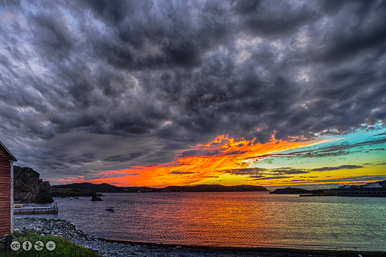 |
A spectacular sky greeted us that night. |
Next day, we accepted John Gillett's invitation to go out in his boat. We had told him we wanted to see whales... you can't just order them up! We put on our waterproofs and off we went in his 19' open whaleboat. But you need to know about John...
He is a sealer, or a "Swiler" as they call them here. He's been at it his whole life, he's my age so that's a lot of years. And, it turns out, he's written a book, called "Leaving for the Seal Hunt (the life of a Swiler)". When we got to our place in Crow Head, what did we find on the bookshelf? Yep. I read it the first night.
John's had a Hell of a life. He's one of those people that PETA hates but you have to hear his side of the story. Sealing is no different from other hunting and without it, the ecological balance changes. There were some 2 million seals when they essentially killed the seal hunt some years ago, now there are more than 6 million of them. Each seal eats a kilo of fish every day, so that's almost 10 million pounds of cod being eaten DAILY, Around a million TONS of fish over a season: an order of magnitude more than man has ever harvested. So the cod fishery has been hugely affected, to the point where it's not commercially viable any more.
He talks about some hard times, in sea and weather conditions we can't imagine (sealing happens in April when the pack ice is still in and people die out there). And he's had some huge fights with the Department of Fisheries and Oceans (DFO) that have cost him his livelihood. Now he's retired for the most part although he still owns a longliner and his son Richard is still in the game. He's a fisherman, though, from herring and cod to lobster and crab. If anyone knows the sea, it's John.
 |
John Gillett in his element. |
In his book, John mentions a fellow sealer colleague called "Skipper Jim". Turns out that Trudy and I had gone out with Jim on his boat last year and Amin and I repeated the event this year. This community owes a lot to these people, streets and whole towns are named after these men. Their history goes back a long time ("I was born here in this house, and that's where my grandpappy lived, and..."). And every inlet, beach and rock formation has a name and a history to go along with it.
We didn't see any whales. It was a nice day but when you pass the breakwater or exit the sheltered harbours, you come to realize that the ocean is not a calm place, most days. Shooting pictures from a pitching boat, especially with the long lens, is a real challenge! We did get a number of interesting shots, though.
 |
One of a million rock faces, seen from the sea |
 |
This is a Black Guillemot in flight |
 |
A pair on a rock face. |
 |
This sea stack, giving us "the finger" is at the base of the cliff below the Long Point lighthouse. |
 |
Here's a night shot of the Twillingate boatyards. Not from the boat... we found an appropriate parking place! |
Fogo Island
The next day, we made the trek to Fogo Island. The ferry ride is short but you can't reserve your space, so we were concerned all day with the possibility that we might not be able to get back. That put a bit of a crimp in our day since we felt we were under time pressure. Turns out we were easily able to get on the late afternoon return ferry.
When we landed on Fogo, we stopped at the tourist info office near the ferry terminal. "Closed for the Season". Huh? Prime time! The height of the tourist season. All around the island we found that places were closed... apparently their season doesn't start until July 1st. One day away. We even had trouble finding a place for lunch, the only restaurants open were at the highway crossroads in the centre of the island and one restaurant in the town of Fogo. Very strange.
 |
"Closed for the season" |
By the way, I was there 12 years ago. The town hasn't changed, still only 2 restaurants. But there are a lot more bed-and-breakfasts and holiday rentals. Their tourist traffic is severely limited by the ferry schedule.
Fogo is different from the rest of Newfoundland. First of all, the geology is different. Apparently a glacier scraped across the land umpteen years ago and left behind a plethora of rocks scattered on the ground.
 |
 |
 |
 |
 |
This is the town of Joe Batt's Arm (I think!) |
and in Joe Batt's Arm is a place many have heard about, the Fogo Island Inn. This high end hotel (that's putting it mildly: suites go for $2800/night, and people like British royalty, the Prime Minister, even Oprah Winfry have visited there) doesn't seem to fit. The town is populated by retirees and blue collar types (if they can find work at all). The Inn caters to the rich. Mention Zita Cobb, the person who made it happen and the world is suddenly Trump/Hilary polarized. They either love her or hate her. Lots of more info via Google or as comments on my Facebook post (have a look).
The ordinary tourist can't access the place. Cars aren't allowed, and you need to have a reservation even to enter the lobby. The odd building towers over the town which is populated by people who can barely make ends meet.
 |
 |
They also built 4 or 5 unique "artist's studios" on the island. Each one is a weird concept shape and yes, it really is skewed like it appears in the picture. I didn't get close enough for a proper picture. |
 |
Atop the town of Fogo is an inland lake. A short hike takes you to this point. Since I only had my 70-200mm lens with me, I created a multi-exposure panorama that resulted in a huge 150Mp file. |
 |
Here's a small crop from the same file after processing in Topaz. |
 |
Another shot on the way down from the lake, showing the town and in the distance, Brimstone Head, thought by teh Flat Earth Society to be one of the four corners of the Earth |
More to come... this took us to the end of June. Stay tuned...
— 30 —
No comments:
Post a Comment